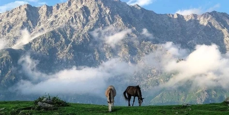
1. Triund Trek, Himachal PradeshTriund Trek is one of the most popular and easiest treks in Himachal Pradesh. It is situated in Kangra Valley, close to McLeod Ganj and Dharamshala and offers excellent views of the Dhauladhar range of peaks and the Kangra valley. The trekking distance is approximately 9 km (one way) and goes through dense oak, deodar, and rhododendron forests, so an excellent weekend holiday. It’s a fairly uniform gradient, picturesque views, and proximity to towns make it the finest trek for nature enthusiasts and newcomers as well.History of Triund TrekEven though the Triund Trek itself is not a historical one, but natural, the region around it is replete with religious as well as cultural heritage. The region is predominantly Tibetan culture because of His Holiness the Dalai Lama's palace at McLeod Ganj. Sheepherders and trekkers used the trek for centuries. Explorers and trekkers have made it the preferred option that it has turned out to be these days because of the convenience of getting there and the Himalayan landscape.Around Places to Visit: Triund TrekMcLeod Ganj: Vibrant town with Tibetan monasteries, cafes, and cultural areas.Bhagsu Waterfall: Quiet waterfall near Bhagsunag Temple, walking distance from McLeod Ganj.Dharamshala is renowned for its cricket ground, monasteries, and serene environment.Indrahar Pass: This pass is suitable for experienced trekkers, with the pass offering a challenging route crossing over Triund.Kareri Lake: Another scenic trekking spot in the region, suitable for off-beat travellers.Best Time to Visit Triund TrekMarch to June: Blue sky, blooming flowers, and nice weather make it the best season to go trekking.September to November: Fresh rain of the monsoon and fewer crowds offer a peaceful trek time.Winter (December-February): It's a snow wonderland, and Triund is snowed out, but the trek is not safe and largely shut down due to heavy snowfall.How to reach Triund TrekBy Airport: The nearest airport is Kangra Airport (Gaggal), roughly some 20 km from Dharamshala. Then taxi or a bus to McLeod Ganj.By Train: The nearest railway station is Pathankot, 90 km away. Taxi or a bus to Dharamshala/McLeod Ganj from Pathankot.By Road: Daily buses and taxis are available from Dharamshala/McLeod Ganj to Chandigarh/Delhi. Good on the road with pleasant hill drive scenery.2. Nag Tibba Trek, UttarakhandNag Tibba Trek is an easy-to-moderate scenery trek in the Uttarakhand district of Garhwal, near Mussoorie. The tallest of the Nag Tibba range of the Lesser Himalayas is Nag Tibba or "Serpent's Peak" at a height of 9,915 feet (3,022 meters) above sea level. Good outing for novices, family, and weekend warriors alike, Nag Tibba provides beautiful views of white-hooded peaks like Swargarohini, Bandarpoonch, Kedarnath, and Gangotri. A trek that passes through dark forests, hamlet homes, and green meadows, the Nag Tibba trek will never leave anyone with anything but sweet memories.History of Nag TibbaNag Tibba is not only worshipped but is also said to be inhabited by Nag Devta, the god of snakes. Prayers for Nag Devta are offered to seek protection from animals and to be in good health. The shepherds and villagers ascended the grasslands from this side. As no knowledge is known in the form of architectural history or efforts of epic warfare, religious mythology and tradition do a wonderful job of providing cultural context.Places Around It to Visit: Nag TibbaMussoorie: "Queen of Hills," Mussoorie is a beautiful hill resort with colonial architecture, shopping, and scenery.Kempty Falls: More scenic waterfalls near Mussoorie, perfect for a weekend trek.Kanatal and Dhanaulti: Peaceful hill stations with forest walks and ecoparks, perfect for nature lovers.Surkanda Devi Temple: A spiritual temple close to Dhanaulti, offering a spiritual experience amidst beauty.Yamunotri: Another Uttarakhand Char Dham, not too far from us for individuals with a longer itinerary.Best Time to Visit Nag TibbaSpring to Summer Season (March to June): Best trekking with fine weather, clear blue sky, and flowering rhododendrons.Autumn to Early Winter Season (September to December): Best trekking with fine weather and dry climate.January to February (winter season): Nag Tibba is a snowland heaven for snow trekking enthusiasts with fresh snowfall and breathtaking Himalayan vistas.How to Reach Nag TibbaBy Airport: The nearest airport is Jolly Grant Airport, Dehradun, 125 km from the trekking base, Pantwari. Taxi service from the airport to Mussoorie or Pantwari village is available.By Train: The nearest railway station is Dehradun Railway Station, well connected with all Indian cities. Taxi or bus journey from Dehradun to Mussoorie or Pantwari.By Road: Car or bus journey from Delhi (approx. 340 km) to Mussoorie or Pantwari. Pantwari is approximately 60 km from Mussoorie by road.3. Kheerganga Trek, Himachal PradeshKheerganga Trek is a very popular trek in Parvati Valley, of Himachal Pradesh's Kullu district. Located at an altitude of approximately 9,750 feet (2,960 meters) above mean sea level, Kheerganga is internationally renowned for its natural hot springs, dense green forest, and sacred landscape. The trekking route begins from Barshaini and is around 12 km in one way and a 4–6 hour ascent. It's simply a great combination of nature, adventure, and tranquillity, which one can get only in the Himalayas and thus is apt for both beginners and backpackers.History of KheergangaKheerganga is abounding with mythology and spirituality. Even Lord Shiva himself, they believe, meditated here for centuries, and even his son Kartikeya did so. "Kheerganga" thus got its name because the hot water spring has milky white streams like "kheer" (rice pudding). It's a pilgrimage centre, and pilgrims thronged to take a bath in hot springs, which were supposed to be medicinal.Points of Interest Around Kheerganga TrekKasol: A Parvati River flowing village and renowned for Israeli cafes, music, and trekkers.Manikaran Sahib: A holy Sikh and Hindu pilgrim destination with hot water springs and a gurudwara, within driving distance from Kasol.Tosh Village: Quiet village near Barshaini with great hill views and a relaxed atmosphere.Malana: An Enchanted village renowned for alternative traditions and hashish, an off-the-beaten-track destination nearby.Rasol and Chalal: Off-the-beaten-path villages with isolation and good forest walks.Best Time for KheergangaMarch and June: Best weather, sky blue, clean, and greenery everywhere make the season the best to trek.September and November: Freshness after monsoons and fewer crowds lead to a peaceful experience.How to Reach Kheerganga TrekBy Airport: The closest airport is Bhuntar Airport (Kullu-Manali Airport), 50 km from Barshaini. Hire a taxi or local vehicle from there to Kasol and then to Barshaini.By Train: The closest railway station is Joginder Nagar, but for most, it is more convenient to take the train up to Chandigarh and then road up to Kasol/Barshaini.By Road: Overnight Delhi bus facility up to Bhuntar or Kasol (12–14 hours). Local transport/drive up to Barshaini up to Kasol, the trek starting point.4. Chopta Chandrashila Trek, UttarakhandAmong the most scenic and rewarding walks of Uttarakhand is the Chopta Chandrashila Trek in the Garhwal Himalayas. The trek provides awe-inspiring visions of tall mountains such as Nanda Devi, Trishul, Chaukhamba, and Kedarnath. The trek starts at Chopta or India's "Mini Switzerland" and ends at Tungnath, the highest Shiva temple in the world, and goes on further to Chandrashila (or "Moon Rock") top at 13,000 feet (4,000 meters). The mid-altitude trek is a mix of nature, faith, and adventure and hence all the more loved by pilgrims and trek enthusiasts.History of Chopta ChandrashilaThe area is rich in mythological and religious connotations. Lord Rama was meditating on Chandrashila peak after defeating the demon king Ravana, according to Hindu mythology. Tungnath Temple on the Chandrashila trail was built by the Pandavas when pilgrims were doing penance and is one of the Panch Kedar temples built for Lord Shiva. Pilgrims' constant interest has been enjoyed for centuries and continues to attract devotees and tourists.Places to Visit Near Chopta Chandrashila TrekWorld's tallest Shiva temple and one of the Panch Kedar temples: Tungnath TempleSunshine lake of Sari village, surrounded by a snowy peak horizon: Deoria TalTown where winter months have deities of Kedarnath being worshipped: UkhimathOne of the Char Dhams that is nearby to be covered as part of an extended vacation: Kedarnath TempleChopta trek offering serene treks and great camp spots: Rohini Bugyal.Best Time to Visit Chopta Chandrashila TrekApril to June (Summer to Autumn): Pleasant weather, pleasant weather, and rhododendrons in bloom create a great combination to visit.Autumn: September to November - Pleasant post-monsoon freshness and unobstructed view of mountains make it suitable for many trekkers.Winter: December to February - The snow lovers would love the trekking holiday during this time to experience the trail and Chopta in snow, but a more challenging climb.How to Reach Chopta Chandrashila TrekBy Airport: The closest airport is Jolly Grant Airport, Dehradun, which is approximately 220 km from Chopta. A taxi can be hired from the airport to bring you to Chopta via Rudraprayag and Ukhimath.By Train: The closest railway station is Rishikesh, which is approximately 210 km from Chopta. You can go to Ukhimath or Chopta directly from Rishikesh by taxi or bus.By Road: Chopta is road-linked to the adjacent big cities of Haridwar, Rishikesh, and Dehradun. One has a frequent daily bus as well as jeeps to Ukhimath, from where Chopta is about 30 km by road.5. Har Ki Dun Trek, UttarakhandHar Ki Dun Trek is the most scenic and culturally based trek of Uttarakhand, located in Govind Ballabh Pant National Park of the Garhwal Himalayas. Being 3,556 meters (11,675 feet) high above sea level, the trek offers mountain views with white-crested summits, alpine meadows, old villages, and glacial streams. Har Ki Dun has also been referred to as the "Valley of Gods" because it is a cradle-shaped valley and is believed to be the route taken by the Pandavas to ascend to heaven. It is a moderately flat trek and an equal opportunity for both veterans and novices alike because it has the ideal mix of adventure, mythology, and nature.History of Har Ki DunThe name "Har Ki Dun" is "Valley of Lord Shiva." The Pandavas travelled via this path to reach heaven in their final journey, as per Hindu mythology. The region has been sacred for centuries, and local villagers even today follow old rituals and customs. Osla and Seema villages en route are over 2,000 years old and possess well-settled Himalayan culture and wooden villages dating back to the Mahabharata era.Places to Visit Around Har Ki Dun TrekOsla Village: Also famous for the temple built in respect of Duryodhana, the Kaurava prince, and also for its distinctive culture.Ruinsara Tal: Lake, surrounded by mountains and meadows, is usually completed as a combined tour with the Har Ki Dun trek.Taluka & Seema Villages: Isolated villages of the Himalayas with wooden hutments and the overall vista.Swargarohini Peak: Visible from Har Ki Dun, the peak is said to be the mythical path to heaven, which was followed by the Pandavas.Govind National Park: A Biodiversity hotspot where Himalayan wildlife like the musk deer, black bear, and monal have been sighted.Best Time to Visit Har Ki Dun TrekAutumn (September to November): Best for photographers and trekkers with blue skies of crystal clearness and unobstructed mountain views.Spring and Summer (April to June): Wildflowers in the valley bloom, and trekking is perfect.Winter (Dec to March): Snow trekking heaven, but the trek is more challenging.How to Reach Har Ki Dun TrekBy Flight: The nearest airport is Jolly Grant Airport, Dehradun, 210 km from the trek starting point at Sankri. Taxis and buses from Dehradun to Sankri are available.By Rail: The closest railway station is Dehradun Railway Station, which is well linked with all the major cities of India. Drive or shared taxi/bus from Dehradun to Sankri (approx. 10 hours).By Road: Sankri can also be approached by road from Dehradun (approx. 200 km). The drive is scenic via Mussoorie, Purola, and Mori. Sankri buses are not regular, and therefore, private/shared taxis are used.6. Brahmatal Trek, UttarakhandBrahmatal Trek is a highly scenic winter trek in Uttarakhand, situated in the Chamoli district of the Garhwal Himalayas. The 12,250-foot (3,735-meter) level hike has a balanced blend of snow tracks, grasslands, icy lakes, and high-altitude mountain country. The cream on the cake of the hike is Brahmatal Lake, 12,250 feet, which was where Lord Brahma sat to meditate and the majesty of mountains such as Mt. Trishul and Mt. Nanda Ghunti. The hike is not too arduous and can be done by new hikers who want to feel snow hiking in the Indian Himalayas.History of Brahmatal TrekBrahmatal has also been named so because Lord Brahma, the creator of Hinduism, used to meditate at this lake. Locals and wisemen have used it as a meditation seat for centuries, and therefore, a sacred place and a natural one. While not nearly as trendy as some of the other Himalayan treks, the trail has become extremely popular in recent years because it is so lovely and has mythic importance.Places to Visit Around Brahmatal TrektheBekaltal: Scenic forest lake on the Brahmatal trail, usually covered in ice in winter.Lohajung Village: Quaint base camp of the trek, providing a glimpse into the surrounding Garhwali life.Ali Bugyal & Bedni Bugyal: Scenic alpine meadows by adding an extra night on the trek.Kausani: Hill station en route to Lohajung with breathtaking Himalayan views.Roopkund Trek (via Junargali Pass): Experienced trekkers can incorporate Brahmatal as part of a circuit trek to mystical Roopkund Lake.Best Time to Do the Brahmatal TrekDecember to February: Actual winter trek with lots of snowfall, frozen lake, and snow forest.March to April: Melting begins for the snow, and rhododendron flowers along the trail, giving colour to the trek.How to Reach Brahmatal TrekBy Airport: The nearest airport is Pantnagar Airport, 220 km away from the Lohajung base village. Taxi and pooled cabs are easily available from the airport to Lohajung.By Train: The nearest head of railway station is Kathgodam, with good road connectivity to Delhi and nearby small towns. A taxi/bus can be hired in a pooled one or a taxi from Kathgodam to Lohajung (drive of approximately 8–10 hours’ duration).7. Dayara Bugyal Trek, UttarakhandDayara Bugyal Trek is one of the most beautiful and gentle treks of Uttarakhand, situated in the Uttarkashi district of the Garhwal Himalayas. "Bugyal" is a local word for a meadow, and Dayara Bugyal, 28 square kilometres, is one of the highest and most stunning high-altitude Indian meadows. A 12,000-foot (3,658 meters) trek provides breathtaking vistas of world-renowned Himalayan peaks like Bandarpunch, Kala Nag, Srikanth, and Gangotri. It is an easy walk, hence ideal for families, visitors, and nature lovers.History of Dayara BugyalDayara Bugyal is pastorally and culturally important for the indigenous Himalayan community. The area has been utilised historically for the summer grazing of cattle. It is also associated with indigenous tradition and festival periods such as the Butter Festival, which needs to be celebrated and pays homage to nature, cattle, and alpine meadows by the villagers of Raithal and Barsu villages. Although not mythologised as other treks, its historical use and indigenous pastoral life make it culturally appealing.Places to Visit Dayara BugyalBarnala Tal: Alpine lake halfway between Barsu and Dayara Bugyal, wooded and ideal for camping.Gangotri: One of the Char Dham, a 3–4 hours' drive from the region.Uttarkashi: A Holy town and scenic place along the Bhagirathi River.Dodital Trek: Another scenic trek, usually undertaken together or as a substitute for Dayara.Bandarpunch Peak Viewpoint: Has excellent sunrise and sunset views of this legendary Himalayan peakBest Time to Visit Dayara Bugyal TrekSummer (April-June): The meadow and grassland are green with patches of wildflowers.Autumn (Sept-Nov): Thin clouding and with scenic mountain view, a dash of crisp post-monsoon flavour.December to February (winter): Best for a snow trek. White meadow and it's a beautiful white wonderland, best suited for skiing and snowshoeing.How to Reach Dayara Bugyal TrekBy Airport: The nearest airport is Jolly Grant Airport, Dehradun, 200 km from Raithal or Barsu, the trek starting villages. Taxi or cab ride-sharing facility from the airport. The nearest railhead is Dehradun Railway Station. It can be reached by road from there (drive for 7–8 hours) via Raithal and Barsu.By Road: Raithal and Barsu are reachable by road from Dehradun or Rishikesh. Shared taxis and normal buses go up to Uttarkashi, which has private cabs available for reaching the base village.8. Tadiandamol Trek, KarnatakaTadiandamol Trek is the most scenic and highest trek in Karnataka in the Kodagu (Coorg) district. Tadiandamol stands at 1,748 meters (5,735 ft) and is the highest peak of Coorg and the third highest in Karnataka. The moderately easy trek, a pleasure for nature enthusiasts, novices, and experienced trekkers alike, is a treat of emerald green shola forest, rolling hills, misty trails, and peeks at the stunning waterfalls of the Western Ghats. It is an ideal weekend retreat from Bangalore, Mysore, and Mangalore.History of TadiandamolTadiandamol, which translates to "great mountain" in Kannada, is a place of great historical and cultural importance. The area was once ruled by the Haleri dynasty, who governed Coorg from the 17th to the 19th century. Nalknad Palace, located at the very foot of the base of the trek, was constructed in the late 1700s as a royal residence. The palace reminds us of the area's historical and architectural depth and adds a touch of culture to the trek.Things to see around the Tadiandamol TrekNalknad Palace: Tiny but interesting palace at the trek's foot, emblem of the royal legacy of Coorg.Chelavara Falls: Scenic waterfall on the trekking path, best seen after the trek.Igguthappa Temple: Foremost temple of Kodavas, situated close by in Kakkabe.Madikeri: District Headquarter of Coorg, famous for Raja's Seat, Abbey Falls, and Madikeri Fort.Kabbe Hills: Another off-beat yet equally picturesque trekking location close to Tadiandamol.Best Time to Visit Tadiandamol TrekOctober to February (Winter): Best time for trekking with wonderful weather, good visibility, and pleasant daytime temperatures.June to September (Monsoon): The track is green and beautiful but slippery; not for beginners.March to May (Summer): Hot but bearable. Clear sky and thin crowd make it beautiful.How to Reach Tadiandamol TrekBy Airport: Nearest are Mangalore International Airport (170 km) or Kannur International Airport (90 km). A taxi or a bus can be taken from there to go to Kakkabe or Nalknad Palace, the starting point.By Train: Nearest railway stations are Kannur (110 km) and Mysore (120 km). From the railway station, bus or taxi and arrive at the base.By Road: Road access is readily available to the trek. Take a drive or ride on the KSRTC bus from Bangalore (260 km) or Mysore (120 km) to Virajpet or Napoklu and proceed thence by taxi or auto to Nalknad Palace, trek starting point.9. Rajmachi Fort Trek, MaharashtraRajmachi Fort Trek is one of the very famous and historically prominent trekking locations of the Maharashtra Sahyadri hills of Lonavala and Karjat. It is a combination of two twin forts, Manaranjan Forts and Shrivardhan Fort, located at an elevation of about 2,710 feet (826 meters). It is enveloped by lush forests, waterfalls, and monsoon-misty hills, thereby making Rajmachi the perfect combination of landscape, history, and adventure. It is perfectly suited for beginners, families, and weekend trekking individuals from Pune and Mumbai.History of Rajmachi FortRajmachi Fort was filled with old and glorious history, much earlier than the Satavahana dynasty rule. It was well-known during the Maratha Empire rule, especially during Chhatrapati Shivaji Maharaj's rule, when he strengthened it to protect the strategic road route of Bor Ghat. It became a part of the Mughals and British later, where it was a key military outpost. Traces of ramparts, water tanks, temples, and ancient fort walls speak volumes about the architectural and strategic significance of the fort over the centuries.Nearby Places around Rajmachi Fort TrekKondhane Caves: 1st century BC, century-old Buddhist rock-cut cave.Shrivardhan Fort: Gaps in for valley views, the taller of the two forts.Manaranjan Fort: Lower top with tanks and bastions, providing a less tiring trekking route.Bhaja and Karla Caves: Ancient rock-cut caves near Lonavala, ideal for historians.Lonavala & Khandala: Hill stations for waterfalls, vistas, and chikki.Best Time to Visit Rajmachi Fort TrekMonsoon (June till September): Everywhere, greenery, foggy conditions, and tiny waterfalls make it a fairy-tale trek. But take care on slippery trails.Winter (October to February): Clear blue sky, great weather, and well-maintained trails, so the best time to visit and shoot.Summer (March to May): Possible, but very hot in the day; an early morning start is advisable.How to Reach Rajmachi Fort TrekBy Train: Karjat can also be reached by local trains from Mumbai and Pune.Trek Distance: Around 6 km one way, but steep and tough.10. Lohagad Fort Trek, MaharashtraLohagad Fort Trek is one of the most sought-after trekking trails of Maharashtra, situated in the Western Ghats, close to Lonavala and Khandala. Towering high at 3,433 feet (1,049 meters) in height, Lohagad is a simple yet rewarding trek for first-time trekkers as well as experienced ones. Enjoyed for its history, natural surrounding landscape views, and its humongous Vishalgarh Fort looming big behind it, the trek is an ideal weekend retreat for visitors who would like to see the heritage and grandeur of Maharashtra.History of Lohagad Fort TrekLohagad means "Iron Fort", and thus its name hides the iron-sturdy, strong fort that it is. The fort was a part of the Maratha Empire and was strategically utilised by Chhatrapati Shivaji Maharaj as a military camp. It was later captured by the British and the Mughals. The most striking feature of the fort is its 'Vinchu Kata' or Scorpion's Tail, a prickly ridge which reveals its defensive structure. The fort served for administrative as well as military purposes and remains part of the glorious heritage of the state.Places to Visit Near Lohagad Fort TrekBushi Dam: Trekking distance from Lonavala, a good spot to witness monsoon and a trek.Karla and Bhaja Caves: Old Buddhist rock-cut caves near Lonavala, of historical interest.Lonavala & Khandala: Hill stations well-known for scenery, waterfalls, and good climate, and thus good places to unwind after your trek.Tiger's Leap: A tourist viewpoint of Lonavala with good views over the valleys below.Pawna Lake: A Relaxed spot around Lohagad for a relaxed break with camping.Best Time to Visit Lohagad Fort TrekTyphoon season (June to September): Green cover, foggy tops, and waterfalls make it one of the most favourite monsoon treks, but the trail might be slippery.Winter (October to February): Ideal weather for trekking with clear skies, cold, and excellent visibility.Summer (March to May): Ideal time for a moderate trek with fewer crosstrees, but might be hot, so early morning starts would be ideal.How to Get to Lohagad Fort TrekBy Airport: The closest airport is Pune International Airport (65 km) or Chhatrapati Shivaji International Airport (Mumbai), 100 km. From Mumbai or Pune, by taxi or private car and then by private car or taxi to Malavali, the nearest railway station.By Train: Malavali Railway Station is closest to Lohagad Fort. Take the immediate 2 km walk or the auto there to the foot of the fort. Lonavala Railway Station itself is a large tourist attraction and is 15 km from Lohagad. Take a taxi or an auto-rickshaw, and rest.Why Book with escape2exploreWhen exploring Treks in Karnataka and beyond, escape2explore stands out as a trusted name in adventure and experiential travel. Here’s why hundreds of travellers choose us for their getaways:Trusted, Well-Reviewed Local Operator: escape2explore has gained the trust of thousands of content tourists all over India. With persistent positive feedback and an unblemished reputation for delivering quality experiences, we assure you that your experience will be hassle-free, memorable, and value-packed. Our insider local knowledge guarantees that you will always be in safe hands.Seasoned Guides: Our trips are led by friendly, trained, and professional guides who are passionate about the outdoors and your safety. Whether it's a beach trek, a cultural tour, or a spiritual walk through temples, our team knows the terrain, the stories, and how to make each moment count.Safe & Curated Itineraries: Your safety is our number one priority. Our tour packages are thoughtfully crafted with safety measures, researched accommodations, and easy travel arrangements. We take care of the details so you can have the experience hassle-free and worry-free.Unique Experience That You Won't Find Anywhere Else: With escape2explore, you discover more than the tourist attractions. We go off the beaten track with hidden beaches, unusual treks, offbeat cultural destinations, and true interactions.Read: Magic of Mukta Top |Magic of Kedarkantha | India on a Dime|Magic of Bali Pass |Family Adventure


